


Quick search for private accommodation

Drvenik Veli (43o27' N - 16o08,9' E) - port
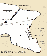 GENERAL: The small village of DRVENIK lies at the far end of the inlet on the NW coast of Island Drvenik Veli. The inlet divides into two parts with the harbor at the far E end of the inlet. A cable comes ashore at the headland between the two parts of the inlet.
APPROACH: There are no dangers in the immediate approach to Drvenik harbor. The harbor can be identified from NW by the houses and the church belfry above the village.
LIGHTS: F.R.4M from the ferry quay within Drvenik, FL.R2s from the peak of the mole to the left
ANCHOR: The usual practice is to anchor near the village in the depths of 8m or on the mole N end of the harbor where is Marina under construction. The bottom is sand. It is possible to take lines ashore, but the depths along side are in general too shallow to permit tying up bow/stern - to.
Do not tie up at the ferry berth.
SHELTER: The harbor is sheltered from all directions.
FACILITIES: No public water tap, shop, post office, two restaurants, ferry to Split and Trogir
Nautical maps shown here are for information use only. Do not use it for navigation purposes.
 All boats coming to Trogir for berthing on Trogir Waterfront should announce their arrival to Harbor Master's Office at least one day before arrival.
Contact: call or send a fax to: +385/21 88 15 08
VHF Channels: 10 & 16
NAUTIC PILOT for ports and anchorages in Trogir Area: Borak, Drvenik Veli, Fumija, Krknjasi, Marina, Okrug Gornji, Racetinovac, Seget, Sicenica, Solinska, Trogir, Vela Rina, Vinisce, Vranjica.
All boats coming to Trogir for berthing on Trogir Waterfront should announce their arrival to Harbor Master's Office at least one day before arrival. Contact: call or send a fax to: +385/21 88 15 08
VHF Channels: 10 & 16
NAUTIC PILOT for ports and anchorages in Trogir Area: Borak, Drvenik Veli, Fumija, Krknjasi, Marina, Okrug Gornji, Racetinovac, Seget, Sicenica, Solinska, Trogir, Vela Rina, Vinisce, Vranjica.
Contact Us |
Terms & Conditions |
Privacy & Security Statements
Copyright 2025 TROGIR OnLine All rights reserved. | Web Hosting | ePoslovanje.hr - eRačuni
Copyright 2025 TROGIR OnLine All rights reserved. | Web Hosting | ePoslovanje.hr - eRačuni